**When Wildfire’s Aftermath Becomes Your Property’s Next Threat**
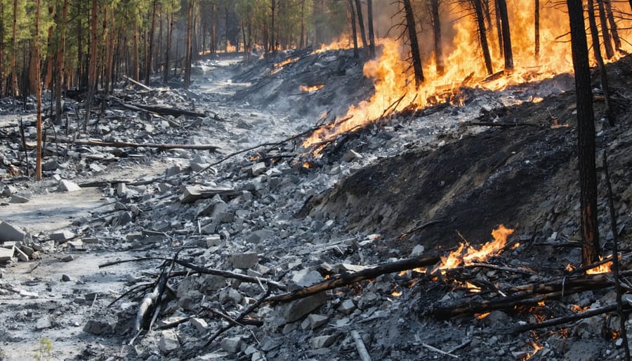
A wildfire may have passed, but your property faces a secondary danger that catches most homeowners off-guard: post-fire debris flows. These fast-moving slurries of mud, ash, boulders, and charred vegetation can race down burned hillsides at speeds exceeding 35 mph, destroying everything in their path—often with as little as 15 minutes warning after rainfall begins.
Unlike typical mudslides, post-fire debris flows occur because wildfire strips away vegetation and creates a water-repellent soil layer, transforming hillsides into slick chutes that channel destructive torrents toward properties below. Standard homeowners insurance policies frequently exclude or limit coverage for this specific hazard, leaving property owners financially exposed to losses that can exceed rebuilding costs when you factor in land restoration and debris removal.
Understanding your exposure isn’t optional—it’s essential due diligence. Properties within a mile of burned areas remain at elevated risk for up to five years following a wildfire, fundamentally altering property values, insurability, and transaction considerations. Whether you currently own property near fire-scarred landscapes or you’re evaluating a purchase in these zones, knowing how to assess risk, secure appropriate coverage, and implement protective measures separates savvy property stakeholders from those facing catastrophic financial consequences.
This comprehensive guide delivers the disaster preparedness essentials you need, from identifying your vulnerability level to navigating complex insurance requirements and implementing physical barriers that could save your investment when the next storm arrives.
What Makes Post-Fire Debris Flows So Dangerous
Why Burned Land Becomes a Slippery Slope
When flames sweep across a hillside, they do more than char the visible landscape—they fundamentally alter what’s happening beneath the surface, transforming stable ground into a ticking hazard for property owners and real estate investors.
During intense fires, extreme heat penetrates several inches into the soil, destroying organic matter and root systems that once held everything in place. Think of these roots as nature’s rebar, creating an invisible network that anchors hillside properties. Once burned away, the soil loses this structural integrity, becoming loose and vulnerable.
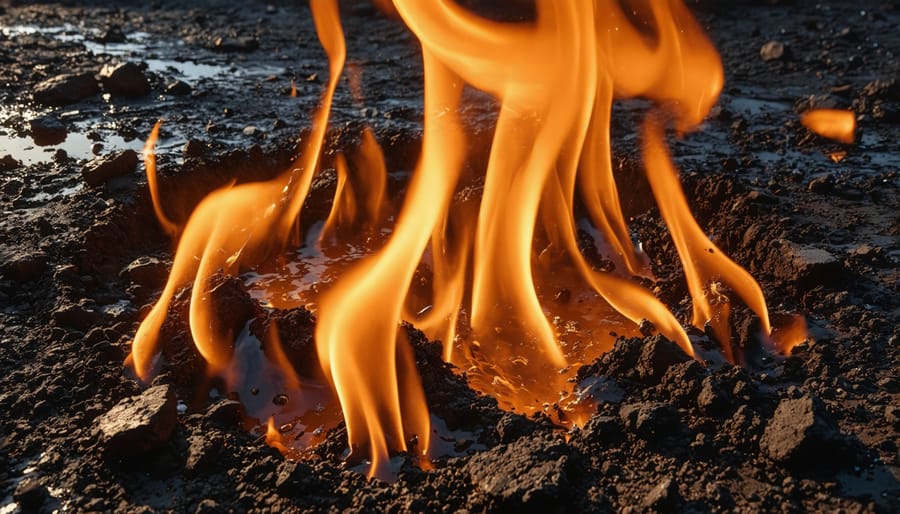
But here’s where it gets particularly concerning for homeowners: fire creates a phenomenon called soil water repellency. When vegetation burns, it releases waxy, water-resistant compounds that seep into the ground and form a barrier just below the surface. Instead of rain soaking into the earth as it normally would, water pools on top and races downhill, picking up speed and volume.
This water repellency can persist for months or even years after a fire, depending on burn intensity and soil type. For property owners in fire-affected areas, this means even moderate rainfall—the kind that wouldn’t normally raise concerns—can trigger devastating debris flows carrying mud, boulders, and charred vegetation.
The combination of loose, unanchored soil and water-repellent layers creates what engineers call a “failure-prone condition.” From an insurance and risk management perspective, understanding this transformation is crucial for protecting your property investment and ensuring adequate coverage before the next storm season arrives.
The Timeline That Catches Homeowners Off Guard
Here’s what many property owners don’t realize: the danger doesn’t end when the fire is out. In fact, the clock starts ticking on a whole new hazard. The most critical window for post-fire debris flows typically spans one to five years after a wildfire, with the first year presenting the highest risk—sometimes up to 40 times greater than pre-fire conditions.
Why does this timeline matter so much? Burned hillsides need time to regenerate vegetation that holds soil in place. Until then, even moderate rainfall can trigger devastating mudflows. For homeowners, this means your property’s risk profile fundamentally changes the moment nearby hills catch fire, even if flames never touched your home. The implications for property values, insurance premiums, and resale disclosures are significant.
Buyers often miss this entirely when purchasing homes months or even years after a wildfire. That “great deal” in a scenic canyon might come with hidden debris flow exposure that won’t show up in standard inspections. Real estate professionals need to recognize this extended vulnerability period when advising clients, as it directly impacts property insurability and long-term investment security.
Identifying Your Property’s Risk Level
Warning Signs Every Property Owner Should Know
Understanding whether your property sits in harm’s way requires examining several critical risk factors. Think of this as your due diligence checklist—similar to inspecting a property before purchase, but focused on nature’s post-fire threats.
**Slope steepness** tops the list. Properties on or below slopes steeper than 30% face significantly elevated risk. Even moderate slopes (15-30%) warrant attention, especially when combined with other factors. Your property doesn’t need to be directly on the hillside—debris flows can travel miles downstream, affecting homes in seemingly safe valley locations.
**Position relative to burned areas** matters tremendously. Properties within or downslope from recently burned watersheds face the highest threat, particularly during the first two years post-fire. The danger extends well beyond the fire perimeter—check if your property lies in drainage paths that originate in burned zones.
**Drainage patterns** reveal nature’s preferred pathways. Does water naturally flow toward your property during storms? Are you located in or near canyon mouths, stream channels, or natural drainage basins? These features become debris flow highways after fires strip away vegetation.
**Soil type** influences both fire intensity and erosion potential. Sandy or gravelly soils erode more readily than clay-based soils, while hydrophobic (water-repellent) soils—common after intense burns—prevent water absorption and accelerate runoff.
**Accessing professional assessments** has never been easier. The USGS provides post-wildfire debris flow hazard maps at https://landslides.usgs.gov, typically updated within days of major fires. Your county’s emergency management office maintains local hazard assessments and historical debris flow data. Many jurisdictions now offer online GIS mapping tools showing hazard zones overlaid with property boundaries—invaluable information for insurance discussions and property valuations.
Don’t skip the historical research. Previous debris flows often repeat along established paths, making past events strong predictors of future risk.
When to Get a Professional Assessment
While basic property assessments help identify obvious risks, certain situations demand expert evaluation. If your property sits within one mile of a recently burned watershed, directly below steep slopes (over 30% grade), or has experienced previous debris flow events, professional assessment isn’t optional—it’s essential for protecting your investment and ensuring accurate insurance coverage.
Qualified geotechnical engineers and engineering geologists specialize in post-fire debris flow analysis. Find certified professionals through the Association of Environmental and Engineering Geologists or your state’s professional engineering board. Real estate professionals should maintain relationships with these experts for due diligence purposes.
Professional assessments typically cost $2,000-$5,000 for residential properties, though complex sites may run higher. These evaluations include detailed slope stability analysis, soil composition testing, watershed modeling, and specific mitigation recommendations. You’ll receive a comprehensive report that’s invaluable for insurance underwriting, property disclosures, and financing decisions.
For potential homebuyers, commission these assessments during escrow in high-risk areas—the cost pales compared to undisclosed hazards. Current homeowners should reassess properties every 2-3 years after major fires, as conditions evolve. Many insurance carriers offer premium discounts when professional assessments confirm implemented mitigation measures, potentially offsetting the evaluation cost over time.
Insurance Coverage Gaps You Can’t Afford to Miss
What Standard Homeowners Policies Actually Cover
Standard homeowners insurance policies create a critical coverage gap that catches many property owners off guard. Here’s the issue: your policy typically covers fire damage comprehensively, but what happens *after* the fire can fall into a murky gray area.
Most policies explicitly cover “fire” as a named peril. They also usually cover “mudslide” or “mudflow”—but here’s where the fine print matters. Insurance companies define mudflow narrowly as earth movement caused by water accumulation on slopes. Debris flow, however, involves the downward movement of burned vegetation, ash, rocks, and soil following wildfire. Many insurers classify this as “earth movement” or “landslide,” which standard policies specifically exclude.
To make matters more confusing, flood insurance through the National Flood Insurance Program (NFIP) covers mudflow but may not fully cover post-fire debris flow either, depending on the specific circumstances and documentation.
This creates a dangerous blind spot. Homeowners who’ve just survived a wildfire understandably assume they’re covered for subsequent damage. They’ve paid premiums, maintained their policies, and followed appropriate fire risk insurance strategies. Yet when debris flows destroy their property weeks or months later, they discover their claims denied due to exclusions they never noticed.
The timing compounds the tragedy—victims face catastrophic loss twice, first from fire, then from debris flow, with potentially only the first event covered. Understanding these distinctions before disaster strikes is essential for proper protection.
NFIP Flood Insurance and Debris Flow: The Fine Print
Understanding your National Flood Insurance Program (NFIP) policy’s fine print is crucial when it comes to post-fire debris flows. Here’s what you need to know: NFIP policies **do cover mudflows**, which are defined as a river of liquid and flowing mud on the surfaces of normally dry land areas. This is good news for property owners facing post-fire debris flows, as these events typically qualify as mudflows under NFIP definitions.
However, there’s a critical distinction that can make or break your claim: mudflows versus landslides. The NFIP specifically **excludes landslides**, which involve the downward movement of earth on a slope. The key difference? Mudflows move like liquid—think flowing, not sliding. If your property damage results from earth movement without that liquid, flowing characteristic, you may find yourself without coverage.
After a wildfire, burned slopes are particularly vulnerable because the loss of vegetation and changes to soil structure create conditions where rainfall triggers liquid mudflows rather than traditional landslides. This generally works in your favor for coverage purposes. Always document the flowing nature of any debris for your claim, and consider consulting with your insurance agent about supplemental coverage for scenarios where the mudflow-landslide line blurs.
Securing Adequate Coverage Before Disaster Strikes
Proactive insurance planning is your strongest financial defense against post-fire debris flows. Start by reviewing your existing homeowner’s policy—standard coverage typically excludes mudflow and debris flow damage, requiring separate endorsements or supplemental policies. Contact your insurance agent immediately to discuss adding climate resilience insurance that specifically covers these hazards.
Timing matters critically: most policies impose 30-day waiting periods before coverage activates, so don’t wait until wildfire season begins. For properties in burn scar areas, act within days of nearby fires being contained.
Document everything for underwriting purposes. Provide assessors with photographs of your property’s drainage systems, slope conditions, and any existing mitigation measures like debris basins or retaining walls. Properties demonstrating proactive risk management often qualify for better rates. Request detailed policy language clarifying what constitutes covered “mudflow” versus excluded “earth movement”—this distinction determines whether claims get approved or denied after disaster strikes.
Property-Level Defense Strategies That Work
Drainage and Diversion Tactics
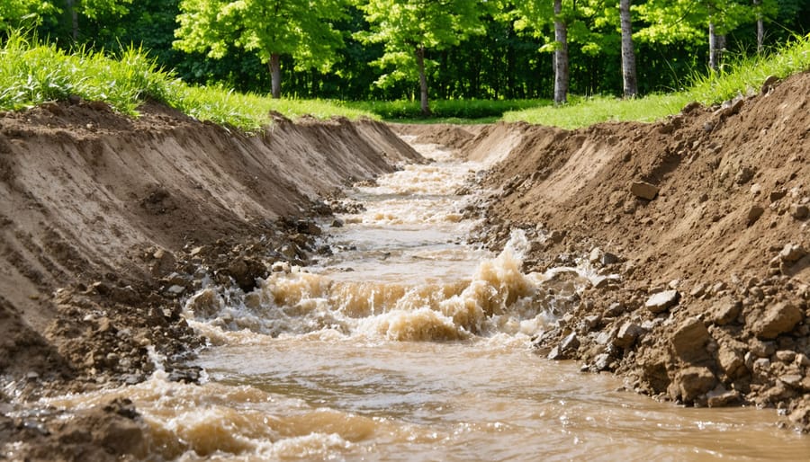
Protecting your property from post-fire debris flows requires strategic water management that redirects dangerous flows before they reach structures. Think of it as creating a controlled pathway that guides mud and debris around—not through—your investment.
**Creating Effective Drainage Systems**
Professional grading around your property establishes the first line of defense. The ground should slope away from buildings at a minimum 2% grade (roughly 2 inches per 10 feet) within the first 10 feet of your foundation. Beyond basic grading, consider installing French drains or subsurface drainage systems on hillside properties to capture and redirect water before it gains destructive momentum.
**Strategic Barriers and Berms**
Earthen berms—engineered mounds of compacted soil—can deflect debris flows around structures when positioned correctly. These typically stand 2-4 feet high and should be placed upslope from buildings, creating a V-shaped channel that funnels flows to safer areas. K-rails (concrete barriers) offer more permanent protection for high-risk properties and can handle greater impact forces than earthen solutions.
**Maintenance Is Your Insurance Policy’s Best Friend**
Even the most sophisticated drainage system fails without regular upkeep. Clear gutters, downspouts, and drainage channels monthly during fire season—debris accumulation reduces capacity by up to 70%. Document all maintenance with photos and receipts; insurers increasingly consider preventive measures when underwriting policies in fire-prone areas. Inspect berms and barriers after each storm, repairing erosion immediately to maintain protection when you need it most.
Remember: proper drainage isn’t just about property protection—it’s a compelling selling point that demonstrates due diligence to future buyers.
Protective Barriers and Emergency Reinforcements
Physical barriers can mean the difference between minor damage and catastrophic loss when debris flows threaten your property. Let’s break down your options based on effectiveness and investment level.
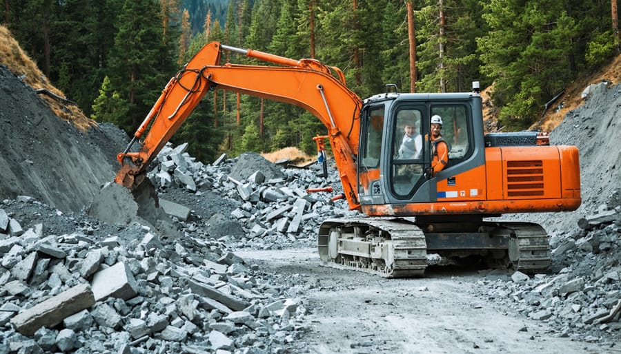
**Debris Flow Barriers** represent the gold standard in protection. These engineered structures—typically made of steel mesh or concrete—can redirect or contain flows carrying tons of mud, rocks, and vegetation. For high-value properties in extreme risk zones, professional installations range from $50,000 to $200,000 depending on property size and terrain. While that sounds steep, consider this: a single debris flow event can cause $500,000+ in structural damage, not to mention the property value impacts we’ll discuss later.
**K-Rail Systems** offer a more accessible middle ground. These modular concrete barriers, commonly seen on highways, can be temporarily installed for $3,000-$10,000 per season. They’re particularly effective when positioned strategically to channel flows away from structures. Many homeowners in moderate-risk areas find this seasonal investment worthwhile, especially during the critical first two post-fire rainy seasons.
**Sandbag Strategies** remain the budget-conscious option at $500-$2,000 for materials and labor. While less effective against high-velocity flows, properly stacked sandbags (pyramid formation, plastic sheeting backing) can divert lighter debris and water. Real estate investors managing multiple lower-tier properties often favor this approach.
**The Bottom Line**: Match your investment to your property’s value and risk profile. A $300,000 home in a high-risk zone justifies engineered barriers; a $150,000 property in moderate terrain makes K-rails sensible.
Landscaping Choices That Reduce Risk
Strategic landscaping serves as your property’s long-term defense against post-fire debris flows. After a wildfire, establishing vegetation quickly becomes critical—roots act as natural anchors that bind soil and slow water runoff. Focus on native, deep-rooted plants adapted to your region’s fire cycle; these species recover faster and require less maintenance than ornamentals, protecting your investment while reducing insurance risk.
Professional erosion control seeding should happen immediately after fire containment, ideally before the first rainy season. These specialized seed mixes often include fast-germinating grasses that provide quick ground cover alongside slower-growing native shrubs for lasting stability. Hydroseeding—where seeds, mulch, and tackifiers are sprayed together—offers particularly effective coverage on steep slopes where traditional planting proves difficult.
Consider terracing or contour planting on hillside properties to interrupt water flow patterns. Real estate professionals should note that properties demonstrating active erosion management often command better valuations and attract more informed buyers. For homeowners, document all professional landscaping work; insurers increasingly recognize vegetation management as a risk-reduction measure that may influence premium calculations or claims settlements in debris flow scenarios.
Creating a Debris Flow Emergency Action Plan
Weather Monitoring and Early Warning Systems
Protecting your property investment starts with staying informed about rainfall conditions in recently burned areas. Download weather apps like the National Weather Service or Weather Underground that provide hourly precipitation forecasts and intensity readings. Property owners should focus on rainfall rates exceeding 0.5 inches per hour, as this typically triggers debris flow warnings in burn scar zones.
Emergency alert systems are your financial safety net—literally. Sign up for your county’s emergency notification system, FEMA alerts, and local fire department notifications. Many insurance companies now offer premium discounts for homeowners enrolled in these services, recognizing their role in loss prevention.
Understanding warning thresholds is crucial for decision-making. Yellow warnings indicate potential debris flow with moderate rainfall, while red warnings demand immediate action. Here’s the key distinction: evacuate when warnings are issued for areas directly below burned slopes, particularly if your property sits in a canyon or drainage path. Shelter in place only applies to properties on higher ground outside direct flow channels.
Real estate professionals should educate clients about these systems during property showings in fire-affected areas. Documenting your emergency preparedness plan can also strengthen insurance applications and potentially reduce premiums by demonstrating proactive risk management.
Document Protection and Financial Recovery Prep
When disaster strikes, your most critical assets aren’t just your property—they’re the documents that prove you own it. Before a post-fire debris flow threatens your area, create a comprehensive documentation strategy that could save you thousands in recovery costs and countless hours of frustration.
Start with your essential documents: property deeds, title insurance policies, mortgage paperwork, and homeowners insurance policies. These aren’t just papers—they’re your financial lifeline. Make high-resolution scans or photographs of every page, ensuring text remains legible even when zoomed in. Store digital copies in multiple cloud-based platforms like Google Drive, Dropbox, or a dedicated service like DocuBank. The redundancy matters; if one platform experiences downtime during a crisis, you’ll have backup access.
For insurance claims, documentation is currency. Walk through your property room by room, creating video footage while narrating what you’re recording. “This is our kitchen with custom cabinets installed in 2022” provides context that static photos can’t capture. Photograph serial numbers on appliances, electronics, and valuable items. Open closets, drawers, and storage areas—insurers need proof of contents, not just structures.
Financial records deserve equal attention. Scan bank statements, investment portfolios, and receipts for major purchases or recent renovations. These establish your property’s value and your financial position for potential recovery loans or insurance negotiations.
Consider investing in a fireproof and waterproof safe for physical copies of irreplaceable documents like original birth certificates and passports. However, remember that even fireproof safes can be swept away in debris flows—digital backups remain your ultimate insurance policy.
Real Estate Transaction Considerations in Fire-Prone Areas
Disclosure Obligations and Liability Issues
When selling property in wildfire-prone regions, understanding disclosure requirements isn’t just good practice—it’s a legal necessity that can save you from costly litigation down the road. Most states with significant fire risk have specific disclosure laws that require sellers to reveal known hazards, including previous fire damage and debris flow susceptibility.
California’s Natural Hazard Disclosure Statement stands as perhaps the most comprehensive example, requiring sellers to disclose whether properties lie within designated fire hazard zones or areas with potential for post-fire landslides. Colorado, Oregon, and other Western states have similar requirements, though specifics vary considerably. Real estate agents should familiarize themselves with their state’s particular mandates—ignorance provides no legal shield.
The disclosure obligation extends beyond past events to known risks. If geological surveys, FEMA maps, or local ordinances identify debris flow zones, sellers typically must share this information. Even informal knowledge—like witnessing mudflows in nearby canyons—may trigger disclosure duties depending on jurisdiction.
Legal exposure for inadequate disclosure can be substantial. Buyers who discover undisclosed hazards post-purchase may pursue claims for rescission, damages, or fraud. Real estate agents aren’t exempt either; they share liability for material omissions that could influence buying decisions. Insurance claims have been denied when carriers discover that known risks weren’t properly disclosed during underwriting.
Effective property risk management starts with transparent communication. Document all disclosures thoroughly, provide buyers with relevant geological reports, and consider requiring professional inspections for properties near burn scars. When uncertain about disclosure requirements, consult real estate attorneys familiar with local regulations—the upfront investment far outweighs potential litigation costs.
How Hazard Zones Affect Property Values and Lending
Properties located in post-fire debris flow hazard zones face significant financial implications that ripple through the entire real estate transaction process. When a home sits within a designated high-risk area, appraisers must factor this vulnerability into their valuations, often resulting in lower assessed values compared to similar properties outside these zones. This isn’t arbitrary—it reflects the genuine increased risk and potential future losses associated with these locations.
Mortgage lenders have become increasingly cautious about financing properties in debris flow hazard zones. Many require additional documentation, including geotechnical reports and mitigation certifications, before approving loans. Some lenders may demand larger down payments—sometimes 25-30% instead of the standard 20%—or impose higher interest rates to offset their risk exposure. In extreme cases, certain lenders simply won’t finance properties in the highest-risk zones, severely limiting the buyer pool.
The insurance landscape presents perhaps the biggest challenge. Properties in debris flow zones often face dramatically higher premiums, reduced coverage options, or outright policy cancellations. When insurance becomes prohibitively expensive or unavailable through standard carriers, buyers must turn to surplus lines insurers or state FAIR plans, which typically cost significantly more and offer less comprehensive protection.
For real estate professionals navigating transactions in these areas, transparency is essential. Disclose hazard zone designations upfront and connect clients with insurance agents specializing in high-risk properties early in the process. Highlight any existing mitigation measures—retaining walls, drainage systems, or debris basins—as these improvements can positively influence both appraisals and insurance availability. Consider timing listings strategically, as insurance markets often tighten immediately following fire events when debris flow risk peaks.
Post-fire debris flows aren’t just a natural disaster concern—they’re a real estate and financial risk that demands immediate attention. Whether you’re a homeowner in a vulnerable area, a real estate professional advising clients, or someone considering property in fire-prone regions, understanding and preparing for this hazard is non-negotiable.
The good news? You now have the roadmap. Start by honestly assessing your property’s risk level using the tools and criteria we’ve outlined. Don’t wait for the next wildfire season to check your insurance coverage—review your policy today to ensure it specifically addresses debris flow damage, not just fire or standard flood coverage. This distinction can mean the difference between full recovery and devastating financial loss.
For real estate professionals, incorporating debris flow risk assessments into your due diligence process protects your clients and your reputation. For homeowners, implementing physical mitigation measures and developing a comprehensive emergency plan safeguards both your family and your single largest financial investment.
The time to act is now, not when evacuation orders are issued. Schedule a property risk assessment, contact your insurance agent to review or enhance your coverage, and create your emergency action plan this week. Your property’s value and your financial security depend on the proactive steps you take today. Don’t let preparation be an afterthought—make it your priority.