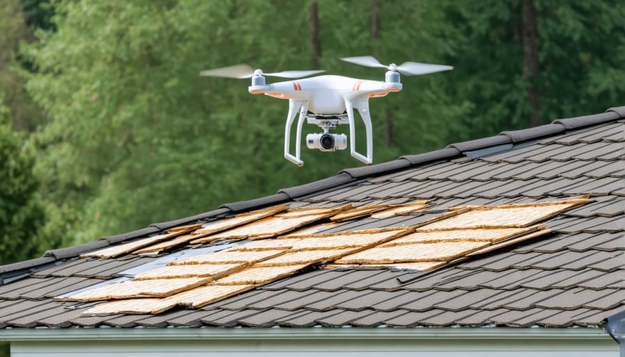
Revolutionizing property insurance assessments, drone technology now enables insurance companies to complete detailed roof and structural inspections in minutes instead of hours, while keeping adjusters safely on the ground. These unmanned aerial vehicles, equipped with high-resolution cameras and thermal imaging sensors, capture precise data about property damage, maintenance issues, and potential risks with unprecedented accuracy and efficiency.
Insurance drone inspections cut assessment time by up to 80% compared to traditional methods, delivering comprehensive aerial imagery and 3D modeling that transforms how claims are processed and risk is evaluated. For insurance companies, this translates to faster claim resolution, reduced operational costs, and enhanced worker safety. Property owners benefit from more accurate assessments, quicker claim settlements, and minimally invasive inspections that don’t require physical roof access.
As regulations evolve and technology advances, drone inspections are rapidly becoming the industry standard for property insurance assessments. Whether evaluating storm damage, conducting routine property surveys, or assessing natural disaster impacts, these aerial platforms provide insurers with detailed, actionable data while dramatically improving the efficiency and accuracy of the claims process.
The Game-Changing Benefits of Drone Insurance Inspections
Speed and Safety First
Drone inspections have revolutionized the insurance assessment process by eliminating the need for dangerous manual inspections while dramatically reducing assessment time. Traditional roof and property inspections often required insurance adjusters to climb ladders, navigate steep slopes, and access hard-to-reach areas, putting them at significant risk of injury. With drones, these hazardous situations are completely avoided.
A typical manual inspection of a residential property might take 1-2 hours or longer, depending on the complexity and size of the structure. Drone inspections can complete the same assessment in just 15-30 minutes, capturing high-resolution images and detailed data from every angle. This efficiency not only speeds up the claims process but also allows insurance companies to handle more assessments per day.
The enhanced safety aspect extends beyond just the inspectors. Drones can safely assess damaged properties in the aftermath of natural disasters, when structural integrity might be compromised. They can also access areas that would be too dangerous or impossible for human inspectors to reach, ensuring a more thorough evaluation without putting anyone at risk. This combination of speed and safety makes drone inspections an invaluable tool in modern insurance assessment practices.
Cost-Effective Precision
Drone inspections are revolutionizing the insurance industry by offering a perfect balance of cost efficiency and precision. Traditional roof and property inspections typically cost between $300 to $600, often requiring specialized equipment and putting inspectors at risk. In contrast, drone inspections can reduce these costs by up to 70%, with average costs ranging from $150 to $200 per inspection.
The advanced imaging technology employed by drones delivers exceptional accuracy through high-resolution photographs, thermal imaging, and 3D mapping capabilities. These features enable insurance adjusters to detect subtle damage patterns and potential issues that might be missed during manual inspections. The digital documentation also creates a comprehensive record that can be reviewed multiple times without additional site visits.
Moreover, drone inspections significantly reduce labor hours and eliminate the need for expensive equipment rentals like cherry pickers or scaffolding. Insurance companies can process claims faster and more efficiently, leading to reduced operational costs and improved customer satisfaction. The return on investment becomes evident within months, as companies can handle more inspections per day while maintaining higher accuracy standards and reducing liability risks associated with manual inspections.
Advanced Technology Behind Drone Assessments
High-Resolution Imaging and 3D Mapping
Modern drone technology has revolutionized property inspection through advanced imaging capabilities that capture stunning detail from multiple angles. These drones are equipped with high-resolution cameras that can shoot in 4K or even 8K quality, ensuring every aspect of a property is documented with crystal-clear precision.
The imaging systems typically combine traditional RGB cameras with specialized sensors, including thermal imaging cameras that can detect heat signatures and identify potential issues like insulation problems or water damage that might be invisible to the naked eye. Many insurance drones also utilize LiDAR (Light Detection and Ranging) technology, which creates precise 3D maps of properties by measuring distances with laser light.
These sophisticated mapping capabilities allow insurance adjusters to generate detailed 3D models of properties, complete with accurate measurements and spatial relationships. The technology can create point clouds – collections of data points that represent the surface of a property – which can be transformed into detailed digital twins of the inspected structure.
The mapping software processes these images and data points to create comprehensive property reports, including roof measurements, facade conditions, and detailed documentation of damage areas. Insurance professionals can then use these digital models to make more accurate assessments, plan repairs, and calculate coverage costs with unprecedented precision. This technology is particularly valuable for accessing hard-to-reach areas and creating before-and-after comparisons following damage events.
AI-Powered Damage Analysis
The integration of artificial intelligence with drone inspection data has revolutionized how insurance companies assess and process property damage claims. Modern insurance technology solutions now employ sophisticated AI algorithms that can analyze thousands of aerial images and data points within minutes, dramatically reducing assessment time while improving accuracy.
These AI systems excel at pattern recognition, automatically identifying various types of damage such as roof deterioration, water damage, or structural issues. The technology uses deep learning models trained on millions of property images to detect anomalies and categorize damage severity with remarkable precision. For instance, AI can distinguish between recent storm damage and pre-existing wear, helping adjusters make more informed decisions about claims.
The analysis process typically involves three key stages: image processing, damage detection, and risk assessment. During image processing, AI algorithms enhance and standardize drone footage for optimal analysis. The damage detection phase employs computer vision to identify specific issues, while the risk assessment stage evaluates the severity and estimated repair costs.
What makes this technology particularly valuable is its ability to learn and improve over time. As more inspection data is processed, the AI becomes increasingly accurate at identifying subtle damage patterns and predicting potential future issues, enabling proactive maintenance recommendations and more accurate premium calculations.
Real-World Applications and Success Stories
Natural Disaster Response
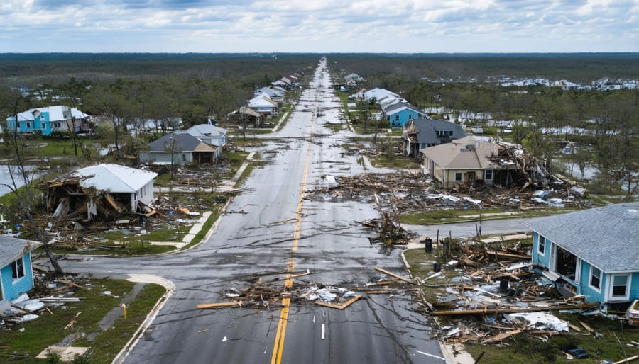
In the aftermath of natural disasters, insurance companies face immense pressure to process claims quickly and efficiently. Drones have revolutionized disaster response strategies, enabling insurers to assess damage across large areas within hours instead of days or weeks.
When hurricanes, tornadoes, or floods strike, drones can safely access affected areas before they’re cleared for human entry. These aerial inspectors capture detailed imagery of damaged properties from multiple angles, creating comprehensive damage assessments without putting adjusters at risk. This rapid response capability means homeowners can receive claim settlements faster, helping communities recover more quickly.
For instance, during Hurricane Harvey in 2017, insurance companies deployed hundreds of drones to assess flood damage, processing thousands of claims in record time. The aerial footage provided clear documentation of water levels, roof damage, and structural issues, streamlining the claims process significantly.
Modern insurance drones equipped with thermal imaging can even detect hidden water damage and structural weaknesses that might be missed in traditional ground-based inspections. This technology ensures more accurate damage assessment and helps prevent overlooked issues that could lead to future problems.
Routine Property Assessments
Regular drone inspections have revolutionized how insurance companies assess and monitor properties, offering a proactive approach to risk management. By conducting routine aerial assessments, insurers can identify potential issues before they escalate into costly claims, while property owners benefit from comprehensive documentation of their asset’s condition over time.
These scheduled inspections typically focus on critical areas like roof integrity, structural elements, and exterior maintenance needs. Drones can capture high-resolution images and detailed data that help track gradual changes or deterioration, enabling insurance providers to recommend preventive maintenance measures that could prevent future damage.
The frequency of these assessments often depends on various factors, including property age, location, and previous claim history. Most insurance companies recommend annual drone inspections, with additional checks following severe weather events or seasonal changes. This systematic approach helps maintain accurate property valuations and ensures appropriate coverage levels.
For property owners, regular drone assessments can lead to more favorable insurance premiums, as demonstrated commitment to maintenance often translates to lower risk profiles. The documentation generated through these inspections also proves invaluable during claims processes, providing historical evidence of property conditions and maintenance efforts.
By embracing routine drone inspections, both insurers and property owners create a more transparent, efficient, and proactive approach to property protection and risk management.
Implementation Considerations for Insurance Companies
Regulatory Compliance and Licensing
Operating drones for insurance inspections requires strict adherence to Federal Aviation Administration (FAA) regulations and specific licensing requirements. Insurance companies and drone operators must obtain a Part 107 Remote Pilot Certificate, which involves passing an aeronautical knowledge test and meeting basic eligibility requirements.
Drone pilots must maintain visual line of sight with their aircraft during operations and follow airspace restrictions. This includes keeping drones below 400 feet above ground level and avoiding restricted areas such as airports and military installations. Additionally, operators must register their drones with the FAA if they weigh more than 0.55 pounds.
Insurance companies must also ensure compliance with state-specific regulations governing drone usage for commercial purposes. Some states require additional permits or have specific privacy laws regarding aerial photography and data collection. Companies must maintain appropriate insurance coverage for their drone operations, including liability insurance for potential accidents or property damage.
Data privacy and security regulations are equally important. Operators must comply with guidelines for storing and handling collected imagery and information, particularly when dealing with personal property. This includes adherence to data protection standards and maintaining secure systems for storing inspection footage and reports.
Regular updates to certifications, ongoing training, and staying informed about changing regulations are essential for maintaining compliance. Insurance companies should establish clear protocols for drone operations and maintain detailed documentation of all flights and inspections.
Training and Infrastructure Requirements
To successfully implement drone inspections in insurance operations, organizations need to invest in both equipment and personnel development. The foundation starts with acquiring commercial-grade drones equipped with high-resolution cameras, thermal imaging capabilities, and advanced sensors. These drones typically range from $2,000 to $10,000, depending on their specifications and capabilities.
Training requirements are equally crucial. Drone pilots must obtain FAA Part 107 certification, which involves passing a knowledge test covering airspace regulations, weather patterns, and operational procedures. Additionally, pilots need specialized training in insurance-specific applications and property risk assessment technology.
Infrastructure needs include secure data storage systems for managing the substantial amount of imagery and data collected during inspections. Organizations should invest in cloud-based platforms specifically designed for drone data management, with features for analysis, reporting, and compliance documentation.
Essential software requirements encompass flight planning applications, photogrammetry software for creating 3D models, and artificial intelligence tools for automated damage detection. Companies should also maintain backup equipment, including spare batteries, propellers, and secondary drones to ensure continuous operations.
A dedicated maintenance schedule and standard operating procedures are vital for ensuring equipment reliability and compliance with safety regulations. Regular calibration and software updates must be factored into the operational framework.
As we look to the future of property insurance assessments, drone inspections are clearly revolutionizing the industry. This technology has transformed what was once a time-consuming, potentially dangerous process into a streamlined, data-rich operation that benefits both insurers and property owners. The adoption of drone inspections has led to faster claim processing, more accurate assessments, and significantly reduced operational costs.
The impact extends beyond mere efficiency gains. Insurance companies are now able to maintain more detailed property records, predict potential issues before they become major problems, and offer more competitive pricing based on precise risk assessments. For property owners, this means quicker claim resolutions, more transparent evaluations, and potentially lower premiums through better risk management.
Looking ahead, we can expect to see even more sophisticated drone technologies incorporating artificial intelligence and machine learning capabilities. These advancements will further enhance inspection accuracy and enable predictive maintenance strategies. As regulations continue to evolve and technology becomes more accessible, drone inspections will likely become the standard method for property insurance assessments, marking a permanent shift in how we approach property risk evaluation and management.